

drought
 Below is the Denton R-C's take on the drought. Actually this version, copied online, was written about Dallas. The Denton paper copied it, substituting "north Texas" for Dallas but not putting in the actual precipitation figures for Denton, which are drier for '05 and wetter for '04: year to date 15.26" last year 51.27". Last year we got around 36" through September, and then another 16 inches on top of that in Oct-Dec. This year we had only 15" through September, and virtually nothing since. According to the
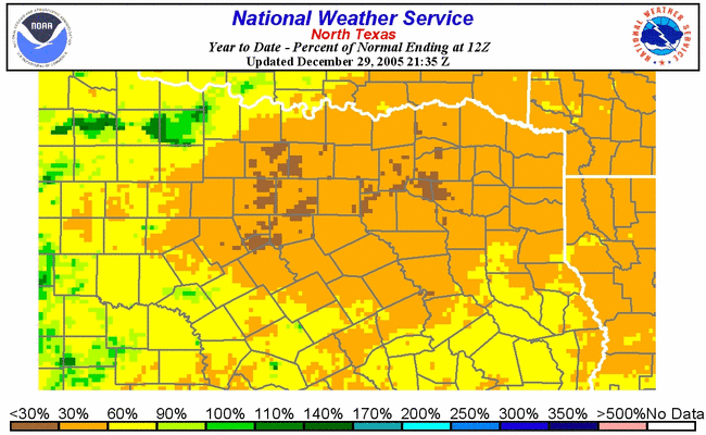
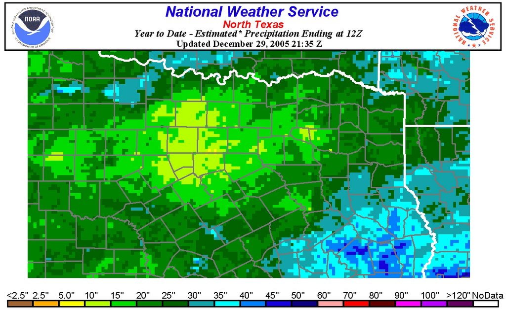 records I can find online ( here ), this is drier than any year in the fifties drought. The upper map is percentage precipita-
tion deficit. The one on the left is this year's precipitation. Denton is in the area that's just about the most drought-stricken, although it looks like the coun-ties just west of us are even a bit worse.
Dehydrated and dangerous, city closing 5th-driest year
Forecasts show little chance for change soon
12:00 AM CST on Wednesday, December 28, 2005
By MICHAEL E. YOUNG / The Dallas Morning News
The last time Dallas endured a year as dry as 2005, Ike had just won his second term and Hollywood queen Grace Kelly became a real-life princess.
So this year is one for the books, the fifth-driest on record and as parched as any in memory – unless your memory goes back to 1956, the worst year of a drought that had gripped the area since 1951.
Assuming it doesn't rain before Sunday – and the National Weather Service sees no likelihood of that – 2005 will end with just 18.97 inches of precipitation, more than 15 inches below normal and less than half of the 47.57 inches recorded in 2004, the fourth-wettest since the weather service began keeping records here.
"It's 180 degrees opposite last year," said Eric Martello, a meteorologist with the National Weather Service in Fort Worth. "Last year, we were issuing flash-flood warnings right and left."
The lack of rainfall this year, especially during the past two months, means North Texas grasslands are tinder-dry.
Combine that with record-high temperatures, low humidity and gusty winds, and the tiniest spark can devour hundreds of acres.
More than a dozen brush fires rolled across rural and suburban pockets of North Texas on Tuesday, destroying a house in Colleyville and threatening two apartment developments near the Tierra Verde Golf Club in Kennedale.
Fires were reported in Aubrey, Burleson, Farmers Branch, Fort Worth and Ponder, across the northern tier of Texas and into central Oklahoma.
Cool fronts should lower temperatures today and again on Friday, Mr. Martello said. But the forecast brings little promise of rain.
"It looks like it's going to be dry right through the New Year," Mr. Martello said, and perhaps much longer than that.
"Right now, we look really short on rain chances for the next couple of weeks," said weather service meteorologist Daniel Huckaby.
The strong westerly winds that kept firefighters on the move Tuesday helped push the afternoon temperature to 82, breaking the record of 81 set in 1971.
Forecasters expect today's cool front to cap temperatures at about 70, Mr. Huckaby said, but that's still 16 degrees warmer than usual, another trend likely to continue.
Thursday morning's low temperature could dip to the lower 40s, but the mercury will climb to the low 70s by afternoon.
And long-range forecasts show no imminent end to the very dry weather, now stretching three months in North Texas.
"Last year, an El Niño supplied a stronger subtropical jet stream, which controls our weather," Mr. Martello said. "This year, it's more of a normal year, and we aren't getting the storm systems or the moist air. Most of that gulf moisture has been streaming up the Mississippi Valley."
And without moisture in the air, most of the passing storm systems do little more than create a canopy of cirrus clouds.
"We just can't seem to get that low-level moisture," he said. "Without that, we aren't getting any rain."
posted by AbigailM | 3:57 AM
![]()
![]()
0 Comments:
Post a Comment
<< Home